Eritrea: flag, capital & map
Get to know Eritrea, then put your memory to work.
Country facts
- Capital
- Asmara
- Region
- Africa
- Subregion
- Eastern Africa
- Population (2025, World Bank)
- 3,607,003
- Area
- 117,600 km²
- Languages (REST Countries)
- Arabic, English, Tigrinya
- Currency (CLDR, October 2026)
- Eritrean Nakfa (ERN)
Eritrea is a country in Eastern Africa. Its capital is Asmara.
Dated population: World Bank; geographic facts: REST Countries; currencies: Unicode CLDR. Sources and dates →
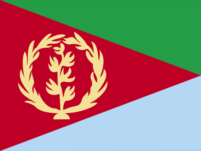
Flag of Eritrea
The flag of Eritrea comprises three triangles — a large red isosceles triangle with its base spanning the hoist end and its apex at the midpoint on the fly end, and a green and blue right-angled triangle above and beneath the red triangle. On the hoist side of the red triangle is a golden vertical olive branch encircled by a golden olive wreath.
Where it is
Eritrea is grouped in Eastern Africa, within Roam’s Africa region. Its land-border list includes 3 countries in this atlas: Djibouti, Ethiopia, Sudan. The source classifies it as not landlocked.
Eritrea has a recorded area of 117,600 square kilometres. Among the 16 countries assigned to Eastern Africa in this dataset, it ranks 10 by area, from largest to smallest. Malawi is immediately above it in that ordering, at 118,484 km². Burundi is immediately below it, at 27,834 km². This comparison uses the source’s area figures and subregions, not a ranking of all territories.
The marker shows the atlas location. Small countries may be too small for an outline at this scale. Map boundaries are illustrative.
People, languages and currency
The World Bank records 3,607,003 people for Eritrea in 2025. This is the latest non-empty annual observation in Roam’s committed 2020–2025 download, rather than a live population counter. Dividing that population by the source area gives approximately 31 people per square kilometre. This calculated average does not describe how evenly people are distributed.
The language entries in the source are Arabic, English, and Tigrinya. They describe the dataset’s listed languages, not every language spoken by residents. The currency listed for this date is Eritrean Nakfa (ERN). Currency assignments are selected from Unicode CLDR’s date ranges for 23 October 2026; the three-letter codes identify currencies, not countries.
Test yourself
Cover the facts above and work through these five questions. Open each answer when you are ready to check it. You can use this section without JavaScript.
What is the capital of Eritrea?
Reveal answer
Asmara. Eritrea is a country in Eastern Africa. Its capital is Asmara.
Without looking at the image, how would you describe the flag of Eritrea?
Reveal answer
The flag of Eritrea comprises three triangles — a large red isosceles triangle with its base spanning the hoist end and its apex at the midpoint on the fly end, and a green and blue right-angled triangle above and beneath the red triangle. On the hoist side of the red triangle is a golden vertical olive branch encircled by a golden olive wreath.
Which land neighbours of Eritrea are included in this atlas?
Reveal answer
Djibouti, Ethiopia, and Sudan. The source classifies Eritrea as not landlocked.
Which languages does the source list for Eritrea?
Reveal answer
Arabic, English, and Tigrinya. These are the source’s language entries, not a complete inventory of every language spoken in Eritrea.
Which currency codes are listed for Eritrea?
Reveal answer
Eritrean Nakfa (ERN). These assignments use Unicode CLDR’s legal-tender date ranges for 23 October 2026.
Try it from memory
5 questions. Answers and feedback appear after each attempt. This short quiz does not change your daily score or saved progress.